Bosse on Massachusetts Maps in Lexington, 7 June
For most of the century, Boston’s market for maps wasn’t big enough to support full-time professionals. Men from other fields tried their hand at making, updating, and publishing local maps.
After the Revolution, military veteran Osgood Carleton established himself as a leading American geographer. The description of this talk says, “From his shop on Oliver’s Dock in Boston, he published navigation and mathematics textbooks as well as maps of Boston, Massachusetts, the District of Maine, New Hampshire, the United States, nautical charts, and a marine atlas, in addition to running a school for navigation, mathematics, and cartography.”
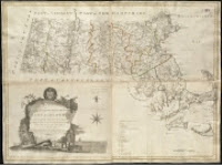
In 1794 Carleton got the Massachusetts legislature’s approval for an “Accurate Map of the Commonwealth of Massachusetts,” shown above. Not that that approval came up with all the cash he needed. Carleton had to raise most of his financing from private subscriptions. Then, the lecture description says, “The complex undertaking became frought with problems when not all Massachusetts towns were able to complete accurate new surveys of the lands within their bounds.” Eventually Carleton did publish a map, of course. But how accurate was it?
Bosse is Librarian of Historic Deerfield and the Pocumtuck Valley Memorial Association, and curator of maps at Historic Deerfield. He was previously a curator at the Clements Library and Newberry Library, and he published articles in Mapping Boston (M.I.T. Press, 1999), the journal Cartographica, and the online journal Coordinates.
This lecture is scheduled to start at 2:00 P.M. It’s free and open to the public.
No comments:
Post a Comment