J. L. BELL is a Massachusetts writer who specializes in (among other things) the start of the American Revolution in and around Boston. He is particularly interested in the experiences of children in 1765-75. He has published scholarly papers and popular articles for both children and adults. He was consultant for an episode of History Detectives, and contributed to a display at Minute Man National Historic Park.

Subscribe thru Follow.it


•••••••••••••••••


Showing posts with label Richard Williams. Show all posts

Friday, May 27, 2022

Maps to Explore from Your Desk

The Leventhal Map and Education Center at the Boston Public Library is offering an “Unrest in Boston 1765–1776” collection of digital images from its collection for educators in grades 3 through 8.

The maps to explore are:
  • William Price’s 1769 update of John Bonner’s 1722 map of the town, showing just the Shawmut peninsula. (I have a print of this on my wall.)
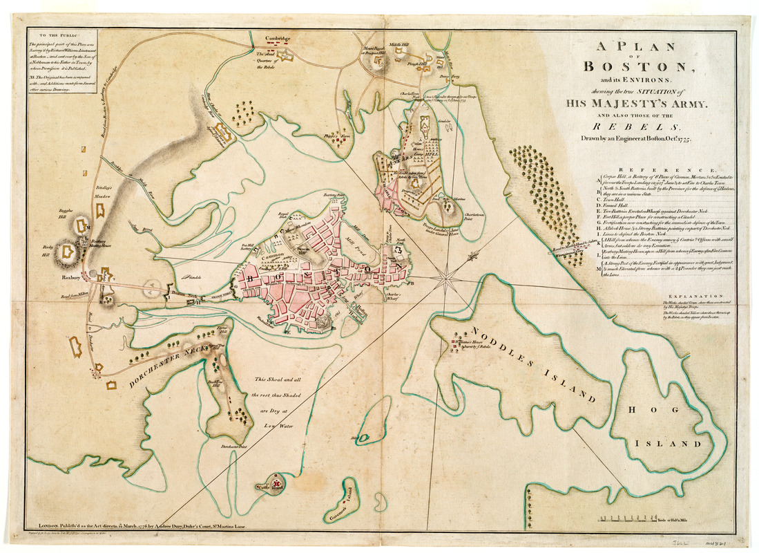
  • Lt. Richard Williams’s map of wartime Boston, the provincial siege lines, and the inner harbor.
  • London publishers Robert Sayer and John Bennett’s “Seat of War, in New England” map of eastern Massachusetts, featuring a little train of figures escorting Gen. George Washington toward Boston.
  • Boston native Isaac de Costa’s map of eastern Massachusetts showing locations from the Battle of Lexington and Concord, including provincial cannon in the countryside.
These maps come with geographic inquiries, supporting documents, and questions for class discussions.

I noted that the overview starts, “Colonial Boston was a flourishing city of 20,000 by the 1760s.” In fact, the 1765 census found 15,520 people in Boston. The surrounding towns, now incorporated into the city, added more people to the area, as did the short-term population of sailors and (at times) soldiers. But this essay makes clear that it counts those soldiers as separate from the town inhabitants.

That census figure is significant not just because of accuracy but also because it hadn’t changed much in decades. Boston was stuck at about 16,000 people while Philadelphia and New York grew larger. What once was Britain’s biggest and busiest port in North America became number three. A frustrating stagnation might have been one reason Bostonians were so easily worked up about imperial taxes in the 1760s.

Before leaving the Leventhal Center, I want to highlight another digitized item from the same decade: This map of the travels of the Qianlong Emperor of China in the fall of 1778.

As an object, this diagram of the imperial route unfolds into an image nearly twenty feet long. (It’s appropriate, therefore, that the interactive feature demands a screen of a certain size before it will show you anything.) The digital presentation comes with helpful explanations by Prof. Anne-Sophie Pratte.

Thursday, June 15, 2017

A Coffin at Bunker Hill

Nathaniel Coffin (1725-80) was a merchant in Boston who in November 1768 took the job of Deputy Cashier to the American Board of Customs.

That shifted Coffin politically onto the side of the royal government. He would even report to his employers about Boston town meetings and private conversations with Whig leaders, but he never hid his distaste for protest and thus wasn’t really undercover.

With Coffin came his sons, John (1756-1838) and Isaac (1759-1839). They both joined the British military during the Revolutionary War and had long and distinguished careers. John became a general, judge, and legislator in New Brunswick. Isaac became an admiral, baronet, and Member of Parliament in England. Since this branch of the Coffin family still had relatives back in Massachusetts, they corresponded and visited with people in the U.S. of A. between and after the wars.

At the start of the war, it appears, John Coffin was a teenager helping to sail a troop transport ship. On 9 Jan 1819, Josiah Quincy (after he served in Congress but before he was elected mayor) recorded a story about Coffin in his diary:
In conversation with William Sullivan. He dined yesterday in company with General Coffin of the British army. Coffin said, that he had the command of the first boat (being then Lieutenant of a transport ship) which landed the advance of the first regiment of British grenadiers at the attack of Bunker’s Hill. As the boat touched the shore, a three-pound shot from the American lines passed lengthways over the boat, touched not a man, and beat out her stern.

Further service with his boat being thus rendered impracticable, Coffin took a musket, joined the assailants, and was in the midst of the battle. He said that he had been since that time in many engagements, but never knew one, for the time it lasted, so hot and destructive.
Quincy evidently wrote this down because “The anecdote proves what has been denied,—that artillery was used on the American side in the battle of Bunker’s Hill.” There’s ample evidence of such artillery from other sources, but American chroniclers had preferred to portray their side as total underdogs. In fact, the diary of Lt. Richard Williams tells us that the provincials were firing five-pound balls, even bigger than what Gen. Coffin described whizzing past him.

The biography of John Coffin published by his son in 1874 goes into more detail, though not necessarily more reliable detail. It said:
John…was sent to sea at a very early age, and served his time in a Boston Ship; being an active young man he soon rose in the estimation of his Captain: in due time became Chief-mate, and soon after was placed in command of the ship, at the early age of eighteen.

In 1774, Mr. John Coffin brought his ship to England; the following year the Government took her up amongst others for the conveyance of troops to America, where the war had commenced. He had on board nearly a whole Regiment with General Howse (in command of the troops), who was ordered out to supersede General [Thomas] Gage, at Boston.
We know Gen. William Howe actually arrived in Boston on 25 May 1775 aboard the Royal Navy ship Cerberus, along with Gen. John Burgoyne and Gen. Henry Clinton. Other ships and soldiers arrived around the middle of June, and Coffin may well have been working on one of those ships instead.
The vessel arrived at Boston, on the 15th of June, Mr. Coffin landed the Regiment immediately under Bunker’s Hill, and the action having already commenced (17th June, 1775), he was requested by the Colonel “to come up and see the fun;” the only weapon at hand being the tiller of his boat, he immediately (to use a nautical phrase) unshipped it, and with equal determination commenced laying about him, and shipped the powder and belt, and musket of the first man he knocked down, and bore an active part during the rest of the action.
This is even more dramatic than the anecdote Quincy recorded, but the only men who would have been within reach of Coffin’s tiller as he was really “laying about him” would have been British soldiers.
In consideration of his gallant conduct, he was presented to General Gage after the battle, and made an Ensign on the field; shortly after he was promoted to a Lieutenant, but still retained the command of his ship.
There’s no documentary support for any of that. John Coffin was commissioned as a captain in the Orange Rangers, a Loyalist corps, in 1777.

Monday, September 19, 2016

Cannon to Reappear at Grotonfest, 24 Sept.

One of the events of this Saturday’s Grotonfest will be the Groton Historical Society’s unveiling of a Revolutionary-era cannon.

The Groton Herald and Nashoba Valley Voice have both run stories about local curator Earl Carter’s work restoring that iron cannon and building a (naval) carriage for it. The Herald’s online story includes a photograph of the markings on the gun, including the royal monogram.

However, in relaying Carter’s understanding of the cannon’s history, the Herald story raises questions:
The cannon was captured when the British gunboat H.M.S. Diana, fitted with four cannon and swivel guns, sailed up Chelsea Creek from Boston Harbor to engage Colonial forces. Exposed to heavy gunfire, the British were forced to abandon Diana at about 10 pm. When British Lieutenant [Thomas] Graves abandoned Diana, he transferred his men to HMS Britannia, which was successfully towed to deeper water. Unmanned, Diana drifted and ran aground on the Mystic River side of the Chelsea coast, tipping onto one side.

American forces, including the eight Groton Minutemen, commanded by Asa Lawrence, boarded the Diana and removed four cannon, one of which is pictured on the front page of the paper. Other American forces rapidly removed everything of value, including other guns, rigging, sails, clothing, and money. They laid hay under the stern to serve as kindling, and the vessel was set on fire at about 3 a.m. to prevent it from falling back into British hands.

Twenty days later, these same four captured cannon were deployed at the Battle of Bunker Hill. Three of the four cannon were lost in the battle, with this one cannon remaining in American hands. Immediately following the battle, a great amount of the armament and gunpowder, including this cannon, were taken to Col. [James] Barrett’s farm in Concord for safe hiding from the British. But, soon, the British learned of this hiding place and sent a large contingent to confiscate these military stores.
The same narrative appears in the video accompanying the Valley Voice article.

However, the “large contingent” of British soldiers sent to confiscate weapons at Barrett’s farm arrived on 19 Apr 1775, one month before the fight over the Diana and two months before the Battle of Bunker Hill.

In addition, the Massachusetts artillery regiment got six cannon onto the Charlestown peninsula during Bunker Hill and lost five—all “4 pounders,” according to Lt. Richard Williams of His Majesty’s 23rd Regiment.

Neither newspaper story lays out the historical documentation for that narrative—which, of course, is not what newspaper stories usually do. But I hope there are clear answers to these questions:
  • What size is this iron cannon? What other physical evidence does the gun itself carry? 
  • What paper trail traces the cannon from the Diana into the New England army and through the war? In researching The Road to Concord I found that Col. Richard Gridley’s Massachusetts artillery regiment did a lousy job with paperwork, and the Continental Army not much better when it came to tracking individual guns.
  • When does this particular cannon surface in Groton records? The town had an unusually active, document-loving local historian in Samuel Abbott Green (1830-1919). I found no mention of a local Revolutionary cannon in his books, even in the section of his Groton during the Revolution that discusses how the Massachusetts Committee of Safety assigned “four six-pounders” to the town on 15 Apr 1775. (It’s not clear the committee had time to ship those guns to Groton before the war began.)
There were cannon in Groton as early as 1808 because the town had its own militia artillery company. In that year (according to Green in his Natural History and the Topography of Groton) the Federalist Columbian Centinel reported that the town’s Independence Day celebration had been spoiled by partisan feuding within the company:
Capt. [James] Lewis [1761-1828], of the Groton Artillery, (a demo[crat].) tho’ courteously invited to appear with his company to celebrate the day, which gave our country birth, not only meanly denied Lieut. [Solomon] Carleton [1773-1856] and his company the use of the cannon on the occasion, but unsuccessfully endeavored to dissuade many from the celebration.
That gathering toasted the “Concord Artillery” instead. Even more specific, at a Lawrence Academy ceremony in 1854, Abbott Lawrence (1792-1855) shared a youthful memory of “the Groton artillery, with their two enormous guns—three pounders.”

According to the Valley Voice, “In 1972, the Groton Historical Society re-discovered [the cannon] behind a building near Lawrence Academy. Someone had built a miniature outdoor display…[but] the barrel was covered in vines ‘30 to 40 years old’.” So the cannon’s provenance seems clear for the last fifty years, at least.

Monday, February 01, 2016

Mad about the Massachusetts Historical Society’s Collections

The Massachusetts Historical Society is celebrating its 225th anniversary this year with, among other things, this online exhibit of 225 notable objects from its collection.

Those objects don’t appear to include the broadside titled “Wolfe’s summit of human glory” which I wrote about here and is one of my personal favorites.

But they do include the Samuel Selden powder horn and many other treasures from the Revolutionary period:
And much more. Some of the material even comes from other historical periods.

Starting today, the M.H.S. is hosting some sort of bracket competition involving 64 of those objects, designated by red dots on the collection page. Since that hasn’t started yet, I don’t know how it works, but I’m sure the webpage will be happy to explain.

In addition, the society’s exhibit on “The Private Jefferson” has opened and will be free to visitors Monday through Saturday until 20 May. There’s also a new illustrated book highlighting Thomas Jefferson documents in the society’s collections.

Monday, September 07, 2015

Map Talk and Exhibit Updates at the Boston Public Library

On Tuesday, 8 September, the Norman B. Leventhal Map Center at the Boston Public Library will host an event titled “Rebels, Redcoats, and Revolutionary Maps.”

It will start with a talk by Richard Brown and Paul Cohen about their book Revolution: Mapping the Road to American Independence, which “looks at the spectacular legacy and importance of early American cartographers.” Of course, some of the most accomplished mapmakers of that time were British.

After the talk there will be a book sale and author signing, and Dr. Ron Grim, Curator of the Leventhal Map Center, will offer a special tour of the “We Are One” exhibition.

That exhibit, which I reviewed back here, was recently revamped with four new items from the King George III Topographical Collection and other collections at the British Library. These include:
The British Library recently shared a blog post about the Williams images.

Also new to the exhibit are a cantonment map from the mid-1760s showing the deployment of British troops in North America, loaned by the Clements Library in Michigan; and one of Amos Doolittle’s hand-colored prints of the British soldiers in Concord in April 1775, loaned by the Connecticut Historical Society.

A lot of the other fine items in the B.P.L. display come from Richard Brown’s collection. His book talk with Paul Cohen is scheduled to start at 6:00 in the Abbey Room on the second floor of the Boston Public Library. It will be preceded by a reception at 5:30 P.M.

Thursday, May 21, 2015

“We Are One” Exhibit Opens in Boston

Earlier this year I recommended the “God Save the People” exhibit at the Massachusetts Historical Society. This month the Norman B. Leventhal Map Center at the Boston Public Library, just a few blocks away on Boyltston Street, opened a new exhibit called “We Are One.” It’s also very good. Both displays are up through the summer, and both are free.

There’s some overlap between the two exhibits. For example, both have copies of the Paul Revere engraving of the Boston Massacre. The B.P.L. also shows the overhead drawing of the killing scene credited to Revere, perhaps used in the legal proceedings that followed. The M.H.S. has two of the musket balls fired that night.

Likewise, both exhibits include a copy of Phillis Wheatley’s 1773 collection of poetry. (Old South Meeting House is also displaying that book now.) The M.H.S. copy of Wheatley’s collection sits alongside what is reportedly her writing desk. The B.P.L. copy contains her signature.

“We Are One” is bigger, with a broader scope. “God Save the People” is focused on greater Boston; it starts with the Stamp Act of 1765 and ends with the Battle of Bunker Hill in 1775. In contrast, the B.P.L. exhibit goes back to trade routes in the mid-eighteenth-century British Empire, the end of the French & Indian War, and the British line of settlement in 1763. It extends through the ratification of the Constitution and the expansion of the U.S. of A. And it covers a lot of ground.

(I’m going to link to a lot of “We Are One” artifacts through the accompanying website. The “God Save the People” exhibit doesn’t have such an elaborate website, but, as this page says, many of its items are visible on the web.)

Because “We Are One” is from a Map Center, it naturally emphasizes cartography. Not just maps, but other ways of visualizing the world. One item I found striking was Georg Balthasar Probst’s view of the London skyline. It’s often said that when Paul Revere and Christian Remick created their view of British troops landing on Boston’s Long Wharf in 1768, they emphasized Boston’s church spires to underscore the town’s religiosity. But Probst’s view of London had even more spires. So was he making the same point, or were church spires the most notable features of any town?

Among my favorite Revolutionary artifacts are the watercolors that Lt. Richard Williams painted on top of Beacon Hill, showing each sector of the view in turn. Back in May 2006 (the month I started this blog), I noted that a set of those had come up for auction. Richard H. Brown has generously loaned them and other items for the “We Are One” exhibit; two originals will be on display in rotation while the whole series is reproduced overhead. Down below you can see me pointing out details of those pictures during a visit earlier this month. (Reproductions of a Williams panorama are also part of the display at the Lexington visitor center of Minute Man National Historical Park.)

Thanks to the B.P.L.’s collections, “We Are One” also goes well beyond cartography. It also includes the gold medal that the Continental Congress commissioned for Gen. George Washington at the end of the siege of Boston. What’s more, beside it is the gorget that Washington wore for his 1772 portrait. That actual gorget. And, back to maps, there’s a 1750 land survey that the teen-aged Washington drew.

Over the next couple of days I’ll discuss a couple of the “We Are One” items in more depth.

Sunday, March 10, 2013

The Truth about Thomas Machin

I’ve been discussing the early life of Thomas Machin, commissioned a lieutenant in the Continental Army artillery on 18 Jan 1776. But what had he been doing before then?

His family left an account that had Machin born to a distinguished British scientist, working for a duke, coming to America in 1772, and quickly joining the movement that led to independence. But there’s no evidence for any of that, and strong evidence against it.

And then there’s this 27 July 1775 entry from the journal of Lt. Richard Williams of His Majesty’s 23rd Regiment of Foot:
Last night Thos. Machin, soldier in our Regt. deserted when sentry on the fire boat in the river near the neck. he went off in the Canoe go to this float, he took the other man’s firelock with him, as it was that man’s turn to lay down, this fellow will give them good intelligence of our Works, for he was a pretty good Mechenik & knew a little of fortification. he invented a new carriage for guns on a pivot &c. his books & instruments were sent for to the General’s.
Lt. Col. Stephen Kemble also noted the desertion that night of a man from the 23rd, “a sensible intelligent fellow, some knowledge of fortification and Gunnery.”

The 23rd Regiment’s muster rolls record that Thomas Machin had enlisted in Maj. Harry Blunt’s company on 17 Feb 1773 and sailed to New York that spring. The regiment arrived in Boston in August 1774. Machin was thus in the army during the Battle of Bunker Hill—but in the British army.

Several people on the American side noted Machin’s arrival, though most didn’t record his name. Col. William T. Miller of Rhode Island wrote on 29 July that “it is thought [he] will prove a very serviceable man to our army, as he is able to give a plan of all the works and fortifications in Boston, and knows all their plans.” The old veteran Jedidiah Preble said he was “as sensible intelligent a fellow as I ever met with.”

Most important, Gen. George Washington wrote down “An Acct. of the Killed & Wounded in the Ministerial Army” based on a conversation with a man he recorded as “John Machin.” The commander-in-chief assigned the deserter to work with his young aide-de-camp, John Trumbull, to draw plans of the British fortifications. (One product of their collaboration appears above.) Later Machin worked for quartermaster general Thomas Mifflin and was most likely a scout during an 8 Jan 1776 raid on British positions at Charlestown.

Machin’s entry in American National Biography says nothing about that activity, accepting the family story of a genteel life in England and a respectable arrival in America. But Machin was a British army private, a deserter, and part of “Washington’s First Spy Ring” during the siege of Boston. I’ll divulge more secrets of the general’s early intelligence efforts this afternoon in Lincoln at an event sponsored by the Friends of Minute Man National Park.

(Thanks to Bob Vogler for posting the quote from Lt. Williams’s diary above to the Revlist in 2002. That sent me hunting for the elusive Thomas Machin.)

Thursday, October 06, 2011

Leventhal Map Center Finding Its Way to New Location

On 22 October, the Leventhal Map Center will reopen to the public in the older McKim wing of the Boston Public Library.

The photo above, from the Boston Globe, shows executive director Janet Spitz in front of a feature of that new space: a map of Boston in 1775 enlarged on glass by the Lynn Hovey Studio. The original is credited to Lt. Richard Williams of His Majesty’s 23rd Regiment of Foot.

In the meantime, check out the center’s Flickr collection as well as its online catalogue.

Wednesday, May 17, 2006

How Boston looked under siege

Ed St. Germain at AmericanRevolution.org alerted me to a website showing effects shots for a History Channel movie called Washington the Warrior. From this link, the fifth example (bottom row, second from left) portrays an explosive moment in the siege of Boston, Apr 1775-Mar 1776.

Our best images of besieged Boston actually come from inside the town because of the all the British officers who had been trained in taking surveys and drawing and had little to do. One of those officers was Lt Richard Williams of the Royal Welch Fusiliers. Some of his sketches were auctioned quite nicely at Bonham's last November. Here's a copy of one of those views, courtesy of the Massachusetts Historical Society. And here's a engraved map published in London based on his drawing, courtesy of the Bodleian Library in Oxford. (Note the name "Mount Whoredom" for the part of Boston now known as the Mount Vernon neighborhood.)