J. L. BELL is a Massachusetts writer who specializes in (among other things) the start of the American Revolution in and around Boston. He is particularly interested in the experiences of children in 1765-75. He has published scholarly papers and popular articles for both children and adults. He was consultant for an episode of History Detectives, and contributed to a display at Minute Man National Historic Park.

Subscribe thru Follow.it


•••••••••••••••••


Showing posts with label Osgood Carleton. Show all posts

Wednesday, January 08, 2025

Cancer Curers in Boston in 1790

Today we think about cancer at a cellular level. In the eighteenth century, cancers were visible growths, usually breaking out of healthy skin.

I don’t know if doctors would consider all such growths as cancers today, but I have no doubt many cases of what we call cancer went undiagnosed back then.

It’s interesting to see that cancer medicine was already a specialty. Indeed, there were doctors who appear to have treated those growths and nothing else.

Osgood Carleton wasn’t even the only Bostonian offering both arithmetic lessons and a cancer cure in the 1790s. John Pope, a Quaker, had been advertising those services since 1779, and after he died in 1796 his wife Hannah took over on the cancer practice.

Toward the end of his career John used the title “Dr.” in his ads. Hannah listed herself as a “cancer doctor” in the 1800 town directory. The Popes’ sons also offered the family cancer cure in other New England towns, as I discussed back here.

To promote his cancer treatment, as quoted yesterday, Osgood Carleton shared testimonials from two women in Haverhill, where he had lived before settling in Boston. In his 1995 article on Carleton, David Bosse suggested that he might have learned this cancer treatment from John Pope, perhaps being the Haverhill agent for that cure.

I think that’s unlikely since Carleton declared that he offered “a Powder, of his own manufacturing,” and never mentioned the more established Pope as a mentor. Indeed, once Carleton moved to Boston, the men were in competition in two fields. I expect there wasn’t much love lost between them.

Unfortunately, cancer specialists like the Popes and Carleton kept their methods secret. That makes it hard to compare their cures, understand how these cures were supposed to work, and assess if they did.

However, the vital records of Haverhill do tell us more about the women who signed those certificates for Carleton in 1787. Elizabeth Lecount, daughter of James and Mary (Davis) Lecount, was born on 14 Sept 1729 and died 23 Mar 1829, or more than forty years after applying Carleton’s powder.

Eunice (Stuard) Cass, widow of William, died 18 Sept 1820. Her birth is not listed in those records, but she and William had children from 1758 to 1775, suggesting she was in her fifties in 1787 and in her eighties when she died. It’s possible the person who signed this certificate was that woman’s teen-aged daughter Eunice, born in 1770; she married Asaph Kendall in 1794 and lived to 1808. Either way, considering the awful symptoms the certificate described, that looks like a success.

TOMORROW: Cancer treatment in Salem in 1790.

Tuesday, January 07, 2025

Osgood Carleton’s Cancer Cure

Mathematics lessons, schoolbooks, almanacs, maps, and surveying and design services weren’t all that Osgood Carleton advertised to the good people of post-Revolutionary Boston.

For three weeks in early 1790, Carleton ran this ad in the Herald of Freedom newspaper:
CANCERS CURED.

MANY Persons have by Cancers, died a painful and lingering death; some of which might have been cured or cut out, but the operation being attended with some pain in cutting, and generally much more in curing without cutting out, has detered many from attempting to save their lives by either, But,

A more simple and easy cure than any formerly practiced is now discovered, as will appear by the following certificates.

Haverhill, June 30th 1787.
I, THE Subscriber certify, that I had a hard lump in the fleshy part of my leg, for more than a year, which was very painful, and was said by persons of skill to be a Cancer near breaking out; on applying a powder I had of Mr. Carleton, it was soon cured, without putting me to any pain, except a very trifling smart at first.
ELIZABETH LE COUNT.

Haverhill, June 30th, 1787.
I, THE Subscriber do certify, that I had a sore on my face, which the physicians called a Rose Cancer, and which for a long time baffled his skill in attempting to cure; it had so far affected my health, as to render me unfit for any kind of business, and greatly affected my eye sight, it emitted such a stench as rendered the room I was in disagreeable to others, and deprived me of my appetite, on applying Mr. Carleton’s powder, my appetite was soon restored, my health recovered, and in a little time the Cancer cured; this was done about a year since, I still remain in perfect health, without any signs of the Cancer breaking out again.
EUNICE CASE.

Many other cures have been effected by this powder, it is now using for a very bad Cancer with prospects of success. It may be had by applying to OSGOOD CARLETON, at Oliver’s Dock, Boston.
A few months earlier, Carleton had included in his almanac for the year 1790 (shown above) the news:
A Cure for CANCERS.—Apply to OSGOOD CARLETON, in Boston, who has a Powder, of his own manufacturing, which, if properly and seasonably applied to a Cancer, has never failed of succress, without putting the patient to any pain.
He promoted this offering again in 1800, adding to his usual text on schooling and surveys in the 12 December Massachusetts Mercury: “CANCERS cured by OSGOOD CARLETON, without cutting or putting the patient to pain.” This treatment wasn’t a major part of his work, but he kept at it for at least a decade.

TOMORROW: Assessing the cancer business.

Monday, January 06, 2025

“He lost some of the country dialect”

Osgood Carleton, the cartographer mentioned yesterday, advertised a lot in Boston newspapers between 1787 and 1808.

In those years he had his school of mathematics and navigation to promote. He had almanacs and other books to sell for a while. Then he sold his maps. He sold design services, and more.

The man’s oddest newspaper notice appeared in the Herald of Freedom in 1790:
Osgood Carleton,
HAVING been frequently applied to for a decision of disputes, and sometimes wagers,* respecting the place of his nativity, and finding they sometimes operate to his disadvantage: Begs leave to give this public information—

that he was born in Nottingham-west, in the State of New-Hampshire—in which state he resided until sixteen years old; after which time, he traveled by sea and land to various parts, and being (while young) mostly conversant with the English, he lost some of the country dialect, which gives rise to the above disputes.

* Several Englishmen have disputed his being born in America.

BOSTON, AUGUST 20, 1790.
In an article for the Massachusetts Historical Society Proceedings, David Bosse tentatively linked Carleton’s accent with a statement in a 1901 profile: as a teen-aged soldier he became a clerk for John Henry Bastide, the British military engineer. If Carleton indeed spent his late adolescence in a British household, his might have ended up with more England than New England in it.

Bosse documents that Carleton lived in Liverpool, Nova Scotia, from 1763 to 1768, marrying there before returning to his home province. Again, that would have exposed him to more British natives than living on a farm in Nottingham, New Hampshire.

But why was it important to make this public pronouncement? One possibility is that being thought British made a man vulnerable to naval impressment. However, the Royal Navy wasn’t at war in 1790, and Carleton wasn’t traveling.

Another is that Carleton understood his potential customers were looking for an American, especially so soon after the war. But Bostonians were quite friendly to British ex-pats in this period, usually welcoming them as converts to republicanism. In a field like cartography, being able to claim European training was probably a plus.

Significantly, Carleton’s ad pointed to “Several Englishmen” disputing or even betting on his background. That might be a way to avoid criticizing local customers, or it might reflect the truth: the men insisting Carleton was British were English themselves.

Carleton was a former Continental Army officer, having enlisted as a regimental quartermaster with the rank of sergeant in May 1775 and risen to lieutenant in January 1777. At the end of 1778 he asked to be listed in the Corps of Invalids for health reasons. Carleton still served until April 1783, taking on administrative tasks like moving money around. After the war, he joined the Society of the Cincinnati.

British visitors to Boston might have heard Carleton speak of those experiences in his British-sounding voice and hinted that he was disloyal—and he might not have liked that. But those visitors weren’t his customers. 

In the end, I suspect that Carleton decided to declare the facts about his birth simply because they were facts. As a teacher, cartographer, and surveyor, he valued precision. He was already a regular advertiser in the Herald of Freedom, so it would have been easy to run this announcement for a week.

Carleton’s singular notice might have arisen from the same impulse depicted in the famous xkcd cartoon: “Someone is wrong on the internet!”

Sunday, January 05, 2025

Mapping Boston in 1795

ARGO (American Revolutionary Geographies Online) offers a new article by John W. Mackey titled “Practical Knowledge and the New Republic.”

It begins:

Perhaps what is most visually striking about Osgood Carleton’s recently rediscovered 1795 map of Boston is its sheer size. At approximately seven feet by six and a half feet, this wall map dwarfs many other Boston maps of the late eighteenth century, including Carleton’s own 1797 work, which until recently was considered the largest Boston map from this period known to be extant in a collection.
This isn’t a printed map but a drawing. The Massachusetts Charitable Mechanic Association donated it to the Leventhal Map & Education Center at the Boston Public Library in 2021. Based on a cartouche dedicating the map “To the Select-Men of the Town of Boston,” curators deduced it was originally town, then city property.

Indeed, volume III of a report on Documents of the City of Boston, for the Year 1879 (published 1880) had an appendix listing “Plans of Boston in the City Surveyor’s Department,” and that included:
Boston, 1795.—An original map. Surveyed by Osgood Carleton for the Select-men.
As for the cartographer:
Osgood Carleton was born to a New England farming family in 1742 and had little schooling. At age 16, he began military service in Nova Scotia during the Seven Years’ War, and he later served in the Continental Army during the American Revolution. While he was born in New Hampshire and appears to have lived for a time in Haverhill, Massachusetts and in Maine, it was in Boston that Carleton made his mark and built the bulk of his career. Armed with mathematical skills presumably gained during his military service, Carleton earned his living putting these skills to practical use: he became a surveyor, a contributor to the ubiquitous almanacs of the era, and the leading cartographer in Massachusetts during his lifetime. . . .

he also left a legacy in his role as a teacher of young men in the City of Boston. . . . he offered on an array of practical mathematical skills from navigation to surveying and mensuration to gunnery, bookkeeping, and the projection of spheres and maps.
Mackey’s article discusses and displays Carleton’s maps of Massachusetts, one of which was eventually printed with state approval, as discussed back here.
The 1795 Boston map captures the town’s post-war transition. Carleton marked the place for the “New State-house” on “State Land.” That new government building would be dedicated that year.

Mackey also discusses how this map didn’t label Oliver’s Dock, though Carleton had used that as a landmark in advertising his school. By 1795 he may have moved to “an unfinished building in Merchant’s Row,” where Robert Bailey Thomas remembered studying under him. Nonetheless, “Oliver’s Dock” was still the official name of that location, preserving the memory of the unpopular royal appointee Andrew Oliver.

Monday, June 02, 2014

Bosse on Massachusetts Maps in Lexington, 7 June

On Saturday, 7 June, the Scottish Rite Masonic Museum & Library in Lexington will host a lecture by David Bosse, Librarian and Curator of Maps at Historic Deerfield, on “Map and Chart Publishing in Boston in the Eighteenth Century.”

For most of the century, Boston’s market for maps wasn’t big enough to support full-time professionals. Men from other fields tried their hand at making, updating, and publishing local maps.

After the Revolution, military veteran Osgood Carleton established himself as a leading American geographer. The description of this talk says, “From his shop on Oliver’s Dock in Boston, he published navigation and mathematics textbooks as well as maps of Boston, Massachusetts, the District of Maine, New Hampshire, the United States, nautical charts, and a marine atlas, in addition to running a school for navigation, mathematics, and cartography.”

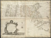
In 1794 Carleton got the Massachusetts legislature’s approval for an “Accurate Map of the Commonwealth of Massachusetts,” shown above. Not that that approval came up with all the cash he needed. Carleton had to raise most of his financing from private subscriptions. Then, the lecture description says, “The complex undertaking became frought with problems when not all Massachusetts towns were able to complete accurate new surveys of the lands within their bounds.” Eventually Carleton did publish a map, of course. But how accurate was it?

Bosse is Librarian of Historic Deerfield and the Pocumtuck Valley Memorial Association, and curator of maps at Historic Deerfield. He was previously a curator at the Clements Library and Newberry Library, and he published articles in Mapping Boston (M.I.T. Press, 1999), the journal Cartographica, and the online journal Coordinates.

This lecture is scheduled to start at 2:00 P.M. It’s free and open to the public.