J. L. BELL is a Massachusetts writer who specializes in (among other things) the start of the American Revolution in and around Boston. He is particularly interested in the experiences of children in 1765-75. He has published scholarly papers and popular articles for both children and adults. He was consultant for an episode of History Detectives, and contributed to a display at Minute Man National Historic Park.

Subscribe thru Follow.it


•••••••••••••••••


Thursday, April 28, 2011

Sculpting the Image of a Shapely Neck

It’s impossible to make sense of colonial Boston without knowing how the town used to be connected to the Massachusetts mainland only by a narrow strip of dry land called the Neck.

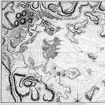
Granted, even with understanding the Neck, not all of colonial Boston’s history makes sense. But that vanished geographical reality is why:
  • The Massachusetts Bay company settled on the easily defended Boston peninsula (after establishing towns at Salem and Charlestown).
  • The British military was able to hold the port against a hostile population from September 1774 to March 1776, and to keep desertion relatively low.
  • Paul Revere and his colleagues arranged the “one if by land, two if by sea” (actually two if by the Back Bay) signals for the different routes out of town.
  • The South End is so much larger than the North End, and north of South Boston.
Bostonians began major landfill projects in the late 1700s, eventually filling in the Mill Pond, the inner harbor, and all the areas that were mudflats at low tide. As a result, there are now many land routes out of central Boston where there used to be one. Today it’s hard to picture the geography the colonists dealt with.

Boston just paid homage to its past as a peninsula by installing a sculptural tribute to the Neck at the corner of Washington and East Berkeley Streets. Here are reports on the dedication from the Boston Globe and South End Patch (which for some reason calls the sculpture “infamous”). 

The sculpture is titled “LandWave.” It includes an engraved map of Boston in the eighteenth century, but some people still think it might be a skateboard ramp. (Not helping is the fact that Landwave is the brand of a company that makes skateboard ramps.)

1 comment:

Robert J. said...

There's an allusion to the filling-in of the Back Bay in Melville's Moby Dick. Boston readers will understand the reference, but probably few people elsewhere do:

"And some certain significance lurks in all things, else all things are little worth, and the round world itself but an empty cipher, except to sell by the cartload, as they do hills about Boston, to fill up some morass in the Milky Way."