J. L. BELL is a Massachusetts writer who specializes in (among other things) the start of the American Revolution in and around Boston. He is particularly interested in the experiences of children in 1765-75. He has published scholarly papers and popular articles for both children and adults. He was consultant for an episode of History Detectives, and contributed to a display at Minute Man National Historic Park.

Subscribe thru Follow.it


•••••••••••••••••


Showing posts with label Paul Dudley. Show all posts

Monday, February 20, 2023

The Power of Specific Names and Details

This month the First Parish in Roxbury published a report by Aabid Allibhai that details the slave-holding by members of its congregation in the colonial period.

I have to admit no surprise at the fact that there were enslavers worshipping in a long-established meetinghouse in a large, prosperous town near Boston in the 1600s and 1700s.

The value of reports like this one (which can be downloaded in P.D.F. form) is bringing personal details out of the records. Here’s one example.

As Wayne Tucker wrote at the Eleven Names Project, in 1916 Great Britain published a volume of its Calendar of State Papers, Colonial Series, covering the years 1706-1708. Its entries summarized the documents and files stored in the Public Records Office. Like indexes and other compilations, such calendars were a valuable way for researchers to know where to look on different topics.

A few of those entries summarized documents in a court dispute involving Massachusetts chief justice Paul Dudley, privateer co-owner John Colman, and an enslaved “negro boy.” See the summary of document 532.i below.

In his report Allibhai reprints a scan of that actual certificate, showing that the child in question was named “Joachim alias Cuffee.”

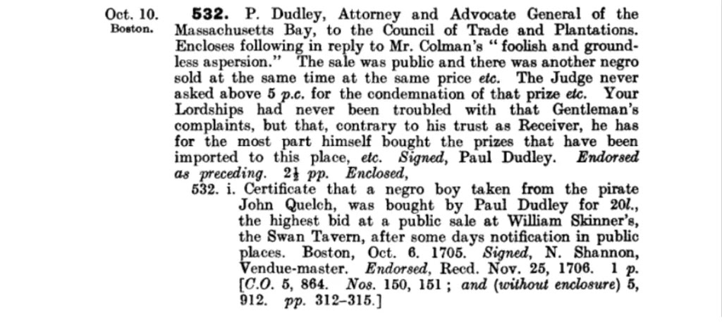
That name was important enough in 1705 for auctioneer N. Shannon to put it into his certificate. But the archivist summarizing that document two hundred years later didn’t think researchers would want to know the boy’s name. That omission reflected the thinking of that time. He wasn’t an important person in this event, just the object of a dispute.

Simply by naming the enslaved child, Allibhai’s report helps to restore his individual humanity. Furthermore, as Allibhai and Tucker show, knowing the boy’s names makes it possible to find other references to him. He was baptized, presumably changing the African day name “Cuffee” for the Christian name “Joachim.” He was no more than fourteen years old. He testified at the trial of the privateering sailors.

The original certificate describes Joachim’s “Publick Sale by the Candle.” This was a form of auction in which a small burning candle served as a timer, and people had to get their best bids in before the candle went out or melted past a certain spot. Samuel Pepys wrote in his diary on 3 Sept 1662 about such an auction:
pleasant to see how backward men are at first to bid; and yet when the candle is going out, how they bawl and dispute afterwards who bid the most first.

And here I observed one man cunninger than the rest that was sure to bid the last man, and to carry it; and inquiring the reason, he told me that just as the flame goes out the smoke descends, which is a thing I never observed before, and by that he do know the instant when to bid last, which is very pretty.
The modern equivalent of waiting until the last second to enter your eBay bid.

Was Joachim present during that auction, watching that candle? The specifics—of the scene, of the boy’s name—can’t help but make the historical moment more compelling.

TOMORROW: A similar document.

Tuesday, July 10, 2018

Rehabbing Colonial Massachusetts’s Granite Positioning System

The Massachusetts Department of Transportation recently announced the completion of its project to preserve the remaining milestones along the old Upper Boston Post Road.

Those stones were initially put in place as early as 1729 by rich men vying for political acclaim, such as justice Paul Dudley (1675-1751), soon to be chief justice. In 1767 the Massachusetts Council ordered more markers. Traffic, urban growth, and highway projects have moved or removed a lot of the stones so that by 1971 only forty were still around to be listed in the National Register.

In 2011, a marker in Brighton was damaged by a truck. That prompted the Transportation Department to explore conserving all the known remaining milestones. In 2014, the Watertown firm Daedalus Inc. was contracted to survey and preserve the markers. The company identified twenty-nine stones that needed repairs, cleaning, cracks filled, resetting, and/or moving back to their original locations. That work is now complete.

The department’s blog post contains a complete list of the surviving markers and their locations. As an example, here’s a stretch of stones in central Massachusetts:
  • Milestone Marker #35 is located at Dean Park on Main Street in Shrewsbury. This granite marker is inscribed with “Boston 35 Springfield 65 Albany 165”.
  • Milestone Marker #43 is located on Main Street at the I-290 ramp in Shrewsbury. This granite marker is carved with the inscription “43 Mile to Boston”. Marker #43 has been moved to a more accessible location on the Shrewsbury Town Common adjacent to Main Street.
  • Milestone Marker #47 is located on Lincoln Street in Worcester. This brownstone marker is carved with the inscription “47 Miles from Boston 50 Springfield”.
  • Milestone Marker #48 was formerly located at the Worcester Historical Society, but, as part of the project, has been reset at Wheaton Square Park on Salisbury Street in Worcester. This brownstone marker is carved with the inscription “48 Miles from Boston”.
  • Milestone Marker #53 is located on Main Street in Leicester. This brownstone marker is carved with the inscription “53 Mile from Boston”.
  • Milestone Marker #54 was formerly located inside the Leicester Public Library, but has been relocated to Washburn Square in Leicester, which is within the vicinity of its original site. This brownstone marker is carved with the inscription “54 Miles from Boston”.
Markers 56 to 74 (the numbers indicating the miles to Boston) have all survived. In contrast, only one marker to the west of that stretch remains, and it was moved into the Springfield Armory Museum.

For more about Massachusetts milestones, see this guest blogger post from Charles Bahne.

Monday, May 07, 2012

Milestones of Greater Boston, Then and Now

Last week Matt Rocheleau reported for Boston.com on the state government’s plan to restore a colonial milestone along Harvard Avenue in Allston that was damaged by a truck. I knew that Charles Bahne, author of the just-published Chronicles of Old Boston, has studied milestones and other early road markings around Boston, so I asked him for his reaction. Charlie kindly supplied this guest blogger essay.

I’m glad to see that the Massachusetts Department of Transportation is overseeing the milestones now, and that the Massachusetts Historical Commission is involved in plans for preserving this one. I’m pleasantly surprised that they have a count of surviving stones— 47 known to exist in situ. I’m sure that there were many more than 99 erected in the colonial era.

The article repeats the myth that the stones mark the “distance from a stone near City Hall in downtown Boston”—referring to the Boston Stone on Marshall Street. All of the colonial stones in the immediate Boston area were erected before 1735, thus before the Boston Stone was set in a public place. The actual zero point was the northwest corner of the Old State House, today’s State and Washington Streets.

It also does not appear that the Allston 6-mile stone was ever part of a mail delivery system; it was erected before the establishment of an official colonial post office and was never along any of the established post roads.

Rather, most of the stones in the immediate Boston area were erected by prominent political figures, such as Samuel Sewall, Jonathan Belcher, and Paul Dudley. I’m guessing that those men saw the milestones partly as a public service, and partly as a billboard advertising their beneficence—just as we see signs near highway construction projects that give the names of government officials today.

There were originally eight milestones along the road from Boston to Cambridge (Harvard Square). Of these, the stones at 1, 2, and 3 miles are now lost. I assume that the 1- and 2-mile stones—and possibly the 3 as well—were lost during the siege of Boston, since they were in a hotly contested area with entrenchments on both sides.

The 4-mile stone still stands on Huntington Avenue in Roxbury. The 5-mile stone is on Harvard Street in Brookline. The 6-mile stone is referenced in this article. The 7-mile stone is on North Harvard Street in Allston. And the 8-mile stone is at the corner of Garden Street & Massachusetts Avenue in Cambridge (slightly moved from its original location in the middle of Harvard Square).

I’ve seen the 3-mile stone on Centre Street in Roxbury and the 5-mile stone at Monument Square (Centre & Eliot Streets) in Jamaica Plain. And of course the “Parting Stone” (not a milestone, but it indicates which route went where) stands at Eliot Square in Roxbury.

I have a copy of an article from the Brookline Historical Society in 1909 reporting the location of several then-existing stones along other highways in Roxbury, Dorchester, Milton, Quincy, Braintree, Canton, Jamaica Plain, and Walpole, in addition to the ones I just mentioned. There is an old milestone in Arlington, near Arlington Heights, which reads simply “8,” and I can’t figure out where that number refers to.

The stones referred to in the article along the Boston Post Road were indeed set up under the instruction of Benjamin Franklin, and in some cases directly under his field supervision. They were erected much later than the stones mentioned in earlier paragraphs.

The Post Road follows U.S. 20 west (with a few modern bypasses) from Watertown Square to about Northborough. At that point U.S. 20 diverges to the south of the Post Road, which goes directly through Worcester. West of Worcester the Post Road follows Mass. Route 9 for several miles, then some other highways, and then rejoins U.S. 20 west of Palmer. In the Springfield area some of the Post Road has been designated as Route 20A.

There were two other routings of the Boston Post Road, one going southwest from Dedham towards Hartford, and one going south from Dedham towards Rhode Island. And in the early nineteenth-century another set of milestones was erected along turnpikes, including the Worcester Turnpike, now Route 9.

As for the sad story of the Allston stone, until about fifteen or twenty years ago it was fairly well protected simply because the city had installed parking meters in that block. The meters defined the parking spaces so that the stone was relatively safe from “attack” by motorized vehicles. When the parking meters were removed, the parking spaces were no longer defined, so people continued to parallel-park in spaces of random length and positions. As a result the milestone was frequently hit and scratched by cars and trucks, a fact which I observed circa 1999. Thus I wasn’t wholly surprised to see that this accident had happened last August.

The other surviving stones along the Roxbury-Allston-Cambridge route are all set back behind the sidewalk, relatively safe from vehicular incursions.

Thanks, Charlie! Part of the plan for restoring the Allston stone is to move it back from the road by about a foot, which would provide a little more protection.

TOMORROW: Milestones on the web.

Tuesday, August 09, 2011

Still Standing in Framingham

From Along the King’s Highway and the Metrowest Daily News, I learned of the following event last Friday:
A Framingham man told police yesterday that he had a “couple too many” before he crashed his car into the Blacksmith Minuteman statue on Union Avenue, police said. . . .

The force of the crash turned the statue 45 degrees, Pereira said.
But the blacksmith was tough enough to survive undamaged. He’s a blacksmith, after all.

According to Framingham Historic Preservation, this Minuteman statue was designed by Henry Kitson, who also did Lexington’s, and executed by his wife Theo Alice Kitson. It was dedicated in 1905 and moved to its current location in 1941, before being moved again very slightly last week.

ADDENDUM: But Universal Hub shows that a colonial-era milestone in Allston wasn’t so lucky, and now needs to be remounted. Charles Bahne tells me:
Despite the date mentioned on the web, it’s a 1729 milestone erected by Paul Dudley, marking six miles from the Old State House. Research I did a few years ago showed that it was discovered in 1916 during excavation of a nearby lot. It’s one of four stones still surviving between Roxbury Crossing and Harvard Business School, all erected by Paul Dudley in 1729. . . . This was the only one of the Dudley stones that was erected this close to the street—all the others are set back behind the sidewalk, some embedded in brick walls.
Dudley (1675-1751) was a son of a colonial governor and former colonial attorney general sitting on the Superior Court when he installed a set of milestones. They can be recognized by his initials or name under the travel information.