
Boston in 1774 with Notes from Later
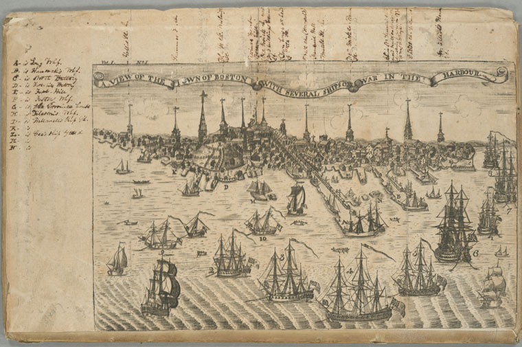
It’s a leaf from Isaiah Thomas’s Royal American Magazine in early 1774 that featured Paul Revere’s engraving of the eastern shore of Boston with Royal Navy ships in the harbor.
This page from the American Antiquarian Society reports that the magazine included a key for this frontispiece inside on page 40. That key identified the labeled landmarks along the water’s edge and the ships. (Though the latter were simply “1,2,3,4,5,6,7 and 8 Ships of War. 9 and 10. armed Schooners.”)
However, this copy of the print was removed from the magazine, and sometime in the early 1800s someone created his or her own key in the margins.
Here’s the handwritten key along the left side; if the key from 1774 said something different, I put that information in brackets:
A- is Long Whf.Originally there was no key for the meetinghouse and church spires dominating the top of the image, but the annotator put a lot of effort into labeling them. And I put a fair amount of effort into reading those labels, including some in pencil that required raising the contrast on those parts of the scan.
B- is Hancock’s Whf.
C- is North Battery
D- is Fort-hill Battery [South Battery]
E- is Fort-Hill
F- is Fosters Whf. [Wheelwright’s Wharf]
G- is the Province house [Beach Hill]
H- is Tilteston’s Whf. [Hubbard’s Wharf]
I- is Hallowell’s Ship Y’d [Hollaway’s Ship-Yard]
K- is [blank] [Walker’s Ship-Yard]
L- is Gee’s Ship Yard [Tyler’s Ship-Yard]
M- is [blank] [Island Wharfs]
N- is [blank] [ditto]
The results are:
Hollis St. Ch.Those labels offer some clues about when the notes were written. The annotator put Old South on “Washington St.,” and that stretch of the street wasn’t officially renamed Washington until 1824. For the Federal Street Church still to be “now Dr. Channings” means that the labels predate 1842. So let’s say around 1830.
Summer St. Ch. [Though was a term for Trinity Church, that building had no steeple; this spire was the New South Meetinghouse on Summer Street.]
First Ch. Federal St.
now Dr. Channings [Rev. William Ellery Channing preached to this congregation from 1803 to 1842; this building was replaced in 1809.]
Old So. Ch. Washington
St. Dr. Eckley’s [Rev. Joseph Eckley’s tenure at Old South ended in 1811.]
Old King’s Chapel
Province house
Beacon light
Old Brick ch. now [?]
Joy’s buildings Cornhill
Sq.
Town house at head
of State St.
West Ch. (Howard’s) [Rev. Simeon Howard died in 1804, and a new church was erected on the site in 1806.]
Faneuil Hall
Brattle St. ch.
New Brick ch. Hanover
St. Dr. Lathrop’s [Rev. John Lathrop died in 1816.]
Ch. in No. Square site
now built over with
dwelling houses. In 1775
it was distroyed. [This was the Old North Meetinghouse.]
Christ Ch. Salem St. [Now best known as Old North Church.]
Dr. Elliot’s Hanover
St. [Rev. Andrew Eliot died in 1778, Rev. John Eliot in 1813.]
It’s a bit confusing that the annotator included the names of some ministers who were dead by that date. I suspect the notes were an attempt to identify who presided over those meetinghouses during the Revolutionary War, at the approximate time of the picture. In the case of Howard, Lathrop, and the older Eliot, they were indeed preaching under those spires in 1774, but Eckley wasn’t installed at Old South until 1780.
2 comments:
A very interesting post, John!
Looking carefully at the original image from NYPL, it appears that the pencilled lines in the legend were added at a later date than the original ink entries. The pencil additions include the references to the church on Federal Street and Old King's Chapel, and to two ministers, Dr. Eckley and Dr. Lathrop.
The reference to Old Brick Church probably reads "now" Joy's buildings [instead of "and"}, "Cornhill" Sq. [instead of "Congress"]. The Old Brick Church was erected in 1713 for the First Church in Boston, across from the Old State House on the site now occupied by the One Boston Place office building. It was an unusual design which is readily identifiable both in this print and in Revere's view of the Boston Massacre. The parish moved to a different part of the city in 1808 and sold the Old Brick building to John Joy who put up "Joy's Building" on its site. Both the Old Brick and the Joy's Building that replaced it were surrounded by a U-shaped public street known as Cornhill Square, later Cornhill Court. Although nearby Cornhill was renamed Washington Street in 1824, as you note, the adjacent alley retained the Cornhill designation into the 1960s. [To make matters more confusing, in 1829 a different street was laid out a few blocks away and was also named Cornhill.]
Also of note, Revere created at least three different versions of this "View of the Town of Boston" with the ships of war landing their troops in 1768. The best-known version was published in April 1770 -- just after the Boston Massacre -- on a single sheet about 10" x 16", with most copies hand-colored by Christian Remick. An earlier, much smaller (4" x 7") version was issued in February 1770 -- just before the Massacre -- as the frontispiece to Edes & Gill's "North American Almanack". The version shown here was issued four years later, included in the January 1774 issue of the Royal American Magazine, about 9" x 13". It was black and white only, never hand-colored.
The three versions of the print share many similar details but were drawn from slightly different perspectives. The April 1770 hand-colored view, for example, has the Old Brick and the Old State House at the extreme left margin, so that Old South, King's Chapel, the Beacon, etc., are cropped out and omitted from view.
While Revere is well known for his copperplate engravings, I was surprised to read a few years ago that Revere also created illustrations in lead and similar metals. The lead illustrations -- sometimes erroneously described woodcuts -- were much less labor-intensive to print and were thus quite a bit cheaper, and could be easily incorporated into the normal print run of a newspaper or book. This version and the April 1770 version were copperplates, while the February 1770 Almanack view was in lead.
Details on all of Revere's prints can be found at the AAS website [http://www.americanantiquarian.org/Inventories/Revere/inventory.htm]
and the many links that can be followed from that page. Look especially for the "Link[s] to Brigham" which have considerably more info.
Thanks, Charlie. I corrected the text about Cornhill Square.
Revere’s cityscapes all seem to owe something to Christian Remick’s view, which Revere engraved. But there was an older British tradition of such views with the steeples standing out above. The earliest such view of Boston appears to date from the 1730s.
Perhaps the most famous of Revere’s “woodcuts” were the coffins he carved in lead for the Boston Gazette after the Massacre.
The A.A.S. website (quoted and linked in the posting above) was built on Clarence Brigham’s study of Revere engravings. It’s my go-to source for Revere’s artwork.
Post a Comment